The Landing Corridor
A straight line on the Earth has no single angle to the equator: Ararat to Giza reads 38° where it starts and 45° where it ends, the only curve with one angle lands 132 km from the pyramid, every '45°' the book names measures 42° to 47°, and the anchors still line up to a percent or two. Six readings, one lottery, two verdicts at equal size.
 Open the interactive ▸
 What you're looking at
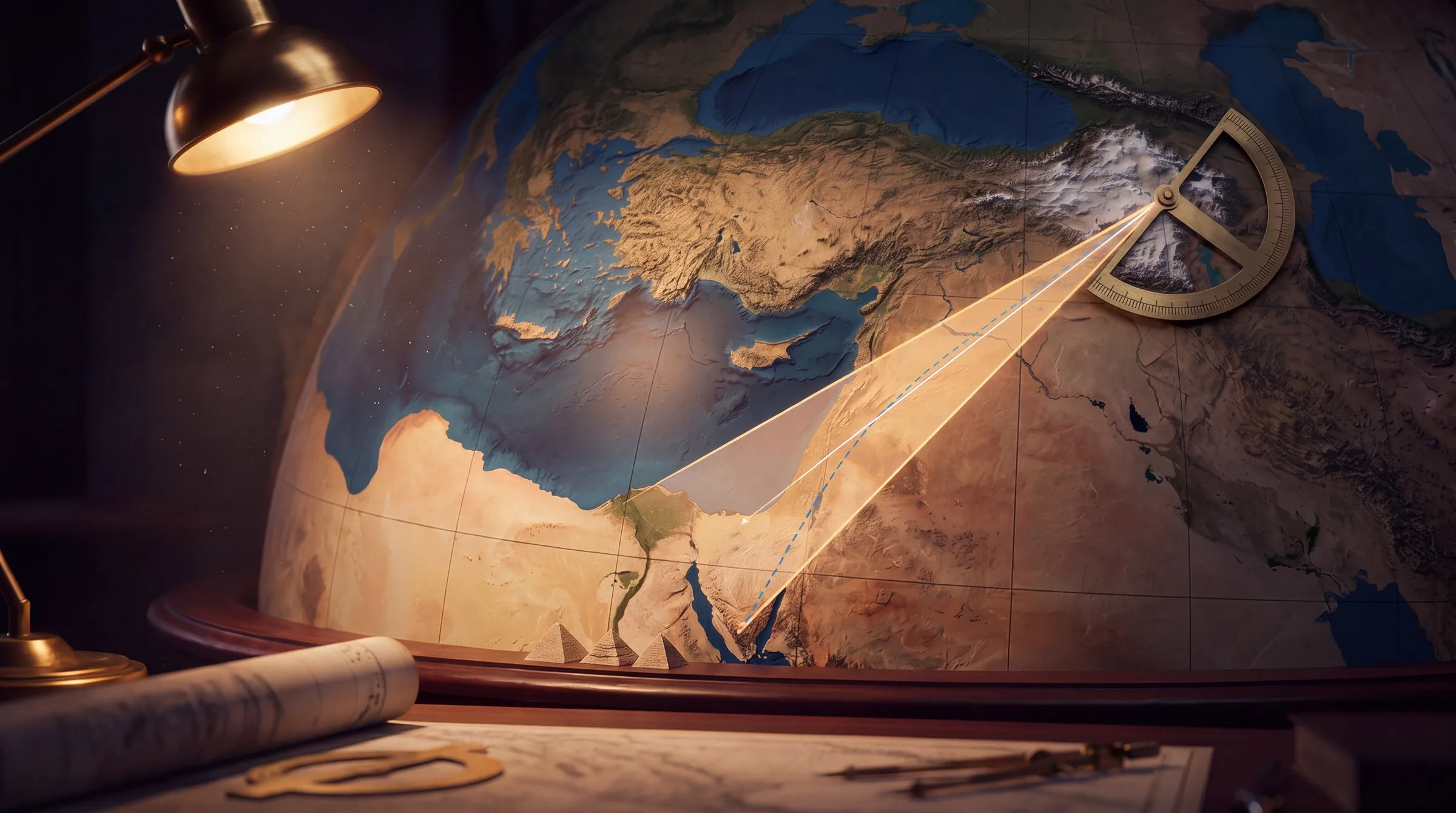
The Corridor is the wedge on the globe in three dimensions. Ararat at the point, the Great Pyramid and Umm Shomar (or St Catherine) at the mouth, Baalbek, Jerusalem and Heliopolis where the book puts them, every line a geodesic on the WGS84 ellipsoid, with the rhumb line between the same two points dashed beside it and a true 45° rhumb from the line's start in blue. Protractors lie on the ground at five points along the chosen line and read its angle to the parallel as it drifts; the ruler at the bottom shows the spread. Switch to Sumer for the first corridor and its meridian, to the Andes for Viracocha's line, and to the stones of Machu Picchu at 150 m.
The Angles measure every line the book draws six ways: the geodesic at its start, its middle and its end; the rhumb line; the same two points on a plate carrée map and on a Lambert atlas sheet. Each is a dot on a 0-90° axis against the 45° band; tap a row and the panel on the right shows how that line's angle drifts from one end to the other and where, if anywhere, it is exactly 45°. The Sheet redraws the book's diagram on a conformal atlas sheet and tests it with its own anchors: whiskers measure how far Jerusalem, Baalbek and Heliopolis sit off the bisector and the Giza edge, dots mark where the bisector, a true 45° rhumb and a true 45° geodesic each meet the 30th parallel, and a ledger prices every construction The Stairway to Heaven and The 12th Planet make, claim by claim.
The Lottery joins every pair among 52 real Near-East summits and sites, 1,297 lines, and bins their angles to the parallel beside 4,000 random pairs in the same box. The histogram is not flat: the land has a grain, shallow angles dominate a wide region, and a bump at 40-50° is the direction the rivers and the Levant coast run; in the Andes a third of all lines fall at 35-45° because the cordillera does. The counts say how many lines sit within the tolerance of 45° under the selected rule, under any rule, and from Ararat alone, against the uniform chance 2 × tolerance ÷ 90°. The Andes run the same way over 22 sites. The File runs thirteen cards, the words first, then the arithmetic, then two verdicts at equal size.
Why it's here
This site's culture wing carries a source note on The Anunnaki Chronicles that splits Sitchin's infrastructure into three layers: a planet (priced on INST-70), a collision (INST-72), and a map. The map is the landing corridor of pages 73 to 75: 'anchored at its point on the twin-peaked Mount Ararat', one edge 'in twin peaks in the Sinai's mountains', the other on markers the Anunnaki had 'to artificially build' because Giza had no natural twin peaks, 'the two great pyramids of Giza'. Page 280 supplies the rule: 'the flight path within this corridor was then inclined at a precise 45 degrees to the equator', Baalbek was 'the landing place for airborne craft', and in the Andes 'the grid followed the same pattern'. Two earlier books draw the diagram in full: The 12th Planet puts the pre-Diluvial corridor over Sumer (spaceport Sippar, mission control Nippur, the cities on a line at 45° to the Ararat meridian), and The Stairway to Heaven puts the post-Diluvial one over the Sinai (the Ararat-Baalbek-Giza line, Mount Umm Shumar as the southern anchor, Jerusalem 'precisely on' the centre line, the spaceport where that line meets the 30th parallel).
It is here because the diagram can be measured, and the book never measured it. Every anchor has a WGS84 coordinate; the line between two coordinates is a geodesic on the ellipsoid, and a geodesic's angle to the parallel changes along its length; the one curve that keeps a single angle is a rhumb line, and a rhumb line is not straight. 'A precise 45 degrees' therefore needs a place on the line and a kind of line, the book gives neither, and each reading gives a different number. This is the site's first geodesy bench: it draws every line the book draws on the Earth with a true 45° beside it, measures each line six ways, tests the book's own constructions with the book's own anchors, then joins every pair of the region's sites and asks how often 45° happens by luck. Some things line up (Jerusalem 10 km off the bisector, Sippar 4 km off Ararat's meridian, Viracocha's line straight to 217 m over 450 km) and some do not (every '45°' the book names measures 42° to 47°), and the bench says both.
How it works
Everything on the bench is arithmetic on coordinates: Vincenty's formulae give every azimuth and distance on the ellipsoid, the isometric latitude gives every rhumb, the projections' published formulae give every paper angle, and a spherical cross-track gives every 'how far off'. The script that ships with the site re-derives every displayed number before the build passes.
α = atan2(cos U₂ sin λ, cos U₁ sin U₂ − sin U₁ cos U₂ cos λ) · angle to parallel = |90° − (α mod 180°)| · rhumb β = atan2(Δλ, Δψ), ψ = ln[tan(π/4 + φ/2)·((1 − e sin φ)/(1 + e sin φ))^(e/2)] · d_xt = asin(n̂ · x̂)·R
The geodesic. Vincenty's inverse solution on WGS84 (a = 6,378,137 m, 1/f = 298.257223563) gives the distance and the azimuths α₁ at the start and α₂ at the end; the direct solution, stepped along the same line, gives the azimuth at any fraction of the distance, which is what the protractors read. The angle to the parallel is |90° − (α mod 180°)|. A geodesic on the ellipsoid differs from the spherical great circle by a tenth of a degree at these lengths; the bench uses the ellipsoid throughout.
The rhumb. A loxodrome crosses every meridian at the same angle, so it has one angle to every parallel; its bearing is atan2(Δλ, Δψ) with ψ the ellipsoidal isometric latitude, and a rhumb of bearing β from a point reaches latitude φ₂ where Δλ = tan β · Δψ. That is how 'a true 45° from Ararat' is drawn, and why it lands 132 km east of Giza. The paper. Plate carrée takes atan2(Δlon, Δlat); Mercator's straight line is the rhumb; the Lambert conformal conic with standard parallels 30° and 40°N (−13°/−16.5° for the Andes) uses Snyder's ellipsoidal constants n, F and ρ. Conformal sheets keep angles at a point, so the protractor readings are true on them locally; a straight line drawn across them with a ruler is a third curve.
The diagram. Cross-track distance is the signed great-circle distance asin(n̂ · x̂)·R on the mean sphere (R = 6,371.0088 km; the ellipsoidal error at these scales is under 0.3%), the line defined by its origin and a point 500 km along its azimuth. The bisector is the mean of the two edge azimuths at Ararat. The angle at Jerusalem between Heliopolis and Umm Shomar is the difference of the two geodesic azimuths there. The lottery. Every unordered pair in a region's site list longer than 50 km is scored under each of the six readings; a hit is within the tolerance of 45°; the uniform chance is exactly 2·tol/90, and 4,000 seeded random pairs in the region's bounding box are drawn beside the real ones as a check on the null and on the 'any rule' inflation.
Nothing is fitted. The only choices are which sites enter the lottery, which parallels the atlas sheet uses, and how far 'precise' stretches; all three are dials, and the null does not move when you turn the first.
The dials that decide what happens
The grid, the line, the Sinai anchor, the camera; the protractors, the rhumb lines, the fill; the region, the tolerance and the measuring rule. Between them they draw every corridor the words could mean, which is itself the exhibit.
- The grid. After the Deluge (Ararat, Giza, the Sinai, Jerusalem, Baalbek, Heliopolis), before it (Ararat, Sippar, Nippur, Bad-tibira, Shuruppak), or the Andes (the Island of the Sun, Cuzco, Ollantaytambo, Tiwanaku, the stones of Machu Picchu).
- The line. Every line the books draw in the chosen grid, labelled edge, centre, cross or path, with its length. The protractors, the drift curve and the status bar follow it.
- The Sinai anchor. Umm Shomar (The Stairway to Heaven's final choice) or St Catherine (its first). Either moves the angles by a tenth of a degree and the bisector by 0.1°.
- Cameras. The wedge, the point (the two Ararats), the mouth (Giza and the Sinai), Sumer, the Andes, the stones (Machu Picchu at 150 m), the Earth.
- Tolerance. ±0.25° to ±5° on 'precise'; ±1° by default. The chance for any line is 2 × tolerance ÷ 90°: 0.6% to 11%.
- Measured how. At the start, at the end, as a rhumb, on a flat map, on an atlas sheet, or any of these. The strict reading is the surveyor's; the generous one is the ruler's.
The claims, as they stand
Eleven claims that make up the corridor, from the 45° rule to the 30th parallel and the Andes, with where each lands when its own anchors are measured.
| 'The flight path within this corridor was then inclined at a precise 45 degrees to the equator' proposed by Sitchin, The Lost Realms; Chronicles p. 280 | REFUTED | A great circle has no single angle to the equator. Ararat → Giza reads 37.9° at Ararat, 42.1° midway, 45.5° at Giza; as a rhumb 41.9°; on a flat map 36.4°. Ararat → Jerusalem, the centre line, reads 44.3° at Ararat and 49.6° at Jerusalem. 'Precise' names no place and no kind of line. |
| The corridor's point on Ararat's twin peaks; one edge on the two great pyramids proposed by Chronicles pp. 73-75 | MEASURED | The two Ararats are 10.5 km apart and subtend 0.35° from Giza; the two pyramids, 475 m apart, subtend 0.0003° from Ararat. As sighting points they are fine; the wedge they define opens 11.7° and is 330 km wide at Giza. |
| 'The Great Pyramid ... is situated precisely on the extended Ararat-Baalbek line' proposed by The Stairway to Heaven ch. 12 | CONTESTED | 22 km off, 0.8° of azimuth, on a 1,613 km line; Heliopolis 21 km off the same line. Close by the standard of an atlas; not 'precisely'. Baalbek is 13 km off the Ararat → Giza geodesic, which passes 540 m from Heliopolis. |
| Baalbek equidistant from St Catherine and Giza; Ararat equidistant from Heliopolis and Umm Shumar proposed by The Stairway to Heaven chs. 12, 14 | CONTESTED | 655 vs 646 km (1.3%); 1,590 vs 1,579 km (0.7%). Jerusalem to Heliopolis vs Umm Shumar, 417 vs 399 km (4.3%). Real to a percent or two, 'exactly' overstated by 9 to 18 km. |
| 'Jerusalem lies precisely on that line', the bisector of the corridor proposed by The Stairway to Heaven ch. 14 | CONTESTED | The bisector of the Giza and Umm Shomar edges at Ararat passes 10 km from the Temple Mount, half a degree at 1,200 km. A real near-alignment; the bench reports it and sends it to the lottery. |
| 'The diagonals drawn from Jerusalem to Heliopolis and to Umm Shumar form an accurate 45 degree right angle' proposed by The Stairway to Heaven ch. 14 | CONTESTED | The one place the 45° is an angle at a point and so has one value: 46.2°, off by 1.2°. |
| Giza, Heliopolis and Eridu 'astride the Thirtieth Parallel'; the spaceport where the centre line meets it proposed by The Stairway to Heaven ch. 14; The 12th Planet ch. 10 | CONTESTED | Giza 2.3 km south of 30°N; Heliopolis 14 km north; Eridu 91 km north. The bisector meets 30°N 213 km east of Giza, in the central Sinai; a true 45° rhumb from Ararat meets it 132 km east, at the peninsula's northern edge. |
| A meridian through Ararat 'bisected the Euphrates' at Sippar; Nippur, Bad-Tibira and Shuruppak on a line at 45° to it proposed by The 12th Planet ch. 10 | CONTESTED | Sippar is 4.3 km off Greater Ararat's meridian, the book's best number. Nippur and Bad-tibira share one azimuth from Sippar to a hundredth of a degree, a real line; it runs at 42.0° to the meridian, not 45°, and Shuruppak is 16 km off a true 45°. |
| 'A line from the Sacred Rock through the slit to the Intihuatana will run at a precise angle of 45 degrees to the cardinal points' proposed by The Lost Realms; Chronicles p. 280 | REFUTED | Sacred Rock → Intihuatana runs 175°, nearly due south (84.9° to the parallel, ±5.8° from ±15 m points). Torreón → Intihuatana runs 317°, 47.0° ± 5.6°, within error of 45°. The three stones are not on one line. |
| Island of the Sun → Cuzco → Ollantaytambo 'precisely at a 45 degree angle to the equator' proposed by The Lost Realms ch. 9 | CONTESTED | The 452 km geodesic passes 217 m from the Coricancha: three sites on one line, the straightest thing in the book. Its angle to the parallel is 42.2° at the island and 42.9° at Ollantaytambo. Straight, and not 45°. |
| What near-alignments at a percent and angles off by three to seven degrees amount to proposed by this bench | READING | Among 1,297 lines between 52 Near-East sites, 33 sit within ±1° of 45° by the strict rule (chance 29) and 120 by the generous one; from Ararat alone, 3 of 51. In the Andes a third of all lines between real sites run at 35-45°, because the cordillera does. The bench prints both readings at the same size. |
Try this
- Start on the Corridor with Ararat → Giza. Press 'the point': the protractor at Ararat reads 37.9°. Press 'the mouth': the one at Giza reads 45.5°. Same line.
- Go to the Angles. The amber curve crosses 45° once, 1,500 km along, over the delta. The dashed blue rhumb sits at 41.9° the whole way. Tap the Jerusalem row: 44.3° at Ararat, the book's best angle, and 49.6° at the far end.
- Go to the Sheet. Read the whiskers: Jerusalem 10 km off the bisector, Baalbek 13 km off the Giza edge, Heliopolis 540 m off it. Read the ledger: the equidistances hold to a percent; the 'accurate 45 degree right angle' is 46.2°. Switch to 'before the Deluge': Sippar 4 km off Ararat's meridian, the city line at 42°.
- Go to the Lottery. 33 hits among 1,297 lines at ±1°, chance 29. Press 'any of these': 120. Drag the tolerance to ±5°: one line in nine by the strict rule. Switch to the Andes and read the histogram: the mountains run at 35-45°.
- Press 'the stones'. Sacred Rock → Intihuatana runs nearly due south; Torreón → Intihuatana 47°. Then 'the Andes' and the Viracocha line: three sites on one geodesic to 217 m, at 42°.
- End on the File. The words, the Giza line, the centre line, the Giza edge, a true 45°, the Sinai peaks, the twin peaks, Sumer, the lottery, Machu Picchu, Viracocha's line, the sheet, then both verdicts.
Accuracy
The honest line between what is reported, what is measured, what is modelled on them, and what is a reading:
| Feature | Status | What that means |
|---|---|---|
| The coordinates | Measured | WGS84 positions of the summits and monuments (Wikipedia and OpenStreetMap points checked against a DEM): Greater Ararat 39.7019°N 44.2983°E, the Great Pyramid 29.9792°N 31.1342°E, Baalbek's Temple of Jupiter, the Temple Mount, Heliopolis's obelisk, the tells of Sippar, Nippur, Bad-tibira and Shuruppak, the stones of Machu Picchu (±15 m), Umm Shomar's summit from a gazetteer (±200 m). The imagery is NASA Blue Marble. |
| Every angle, distance and cross-track | Exact | Vincenty's inverse and direct formulae on the WGS84 ellipsoid give each line's azimuth at its start, middle and end; the isometric latitude gives the rhumb bearing; plate carrée, Mercator and a Lambert conformal conic give the paper angles by their published formulae; cross-track distances on the mean sphere (error under 0.3% here). No parameter is fitted. |
| The lottery’s site list; the sheet’s standard parallels; the generous rule | Modelled | Which 52 Near-East and 22 Andean sites enter the lottery is a choice (prominent summits, famous monuments, the cities the book names); the uniform null, 2 × tolerance ÷ 90°, does not depend on it, and 4,000 seeded random pairs in the same box reproduce it. The Lambert sheet's standard parallels (30°/40°N) are an atlas convention; 'any of six readings' is the allowance a ruler on a map takes. |
| The book’s words | Reported | Every quotation is from The Anunnaki Chronicles with its page, and where the construction comes from The Stairway to Heaven or The 12th Planet the chapter is named. Where the book's number holds (Sippar on the meridian, the equidistances to a percent) the bench says so; where it does not (every 45°), the measured value is printed beside it. |
| What it amounts to | Reading | A wedge whose anchors sit where the book put them to a percent or two, whose every stated angle is off by three to seven degrees, through a lottery that pays 45° to one line in forty: whether that is a flight plan or a ruler on a map is a reading, and the bench declines to make it for you. |
In one line: Every number on the bench is a coordinate or arithmetic on one; the only choices are the lottery's site list, the atlas sheet's parallels and the width of 'precise', and all three are dials. The book's words are quoted with their pages. The reading is yours.
Sources
- Zecharia Sitchin, "The Anunnaki Chronicles: A Zecharia Sitchin Reader", ed. Janet Sitchin (Bear & Company, 2015): the landing corridor and the Sinai spaceport (pp. 73-75), the pyramids as beacons (pp. 78-80), the 45° rule, Baalbek and Machu Picchu (p. 280).
- Zecharia Sitchin, "The Stairway to Heaven" (St. Martin's, 1980), chs. 12 and 14: the short corridor focused on Baalbek with St Katherine and Giza as anchors; the long corridor focused on Ararat with Umm Shumar and Heliopolis; Jerusalem on the bisector; the 30th parallel. "The 12th Planet" (Stein and Day, 1976), ch. 10: the Ararat meridian, Sippar, the 45° city line. "The Lost Realms" (Avon, 1990), ch. 9: Machu Picchu and the Viracocha line.
- T. Vincenty, "Direct and Inverse Solutions of Geodesics on the Ellipsoid with application of nested equations", Survey Review 23 (1975): the geodesic formulae used throughout, on WGS84 (NIMA TR8350.2: a = 6,378,137 m, 1/f = 298.257223563).
- J. P. Snyder, "Map Projections: A Working Manual", USGS Professional Paper 1395 (1987): the ellipsoidal isometric latitude and Mercator (pp. 41-47), the Lambert conformal conic with two standard parallels (pp. 104-110), plate carrée (pp. 90-91).
- Wikipedia (CC BY-SA) and OpenStreetMap (ODbL) coordinates for the summits, monuments and tells, checked against ASTER GDEM v3 elevations through OpenTopoData; Umm Shomar from the Mapcarta gazetteer; Machu Picchu's Intihuatana, Sacred Rock and Torreón as OpenStreetMap nodes (±10-20 m).
- NASA Earth Observatory, "Blue Marble: Next Generation" with shaded relief and bathymetry (public domain), served through the NASA GIBS web map service at 4 km (globe) and 1 km (regional sheets) per pixel.
- Natural Earth 1:110m coastlines (public domain), as baked for this site's Piri Reis and Crust Displacement benches.
- W. M. F. Petrie, "The Pyramids and Temples of Gizeh" (Field & Tuer, 1883): the Great Pyramid's latitude and orientation; the 2.3 km south of the 30th parallel.
- María Schulten de D'Ebneth, "La Ruta de Wiracocha" (Lima, 1953): the 45° grid Sitchin adopts for the Andes, cited in The Lost Realms.
Put the wedge on the Earth. Then read the protractor at both ends.
Open the interactiveCompiled August 2026