The Westall Two-Channel Bench
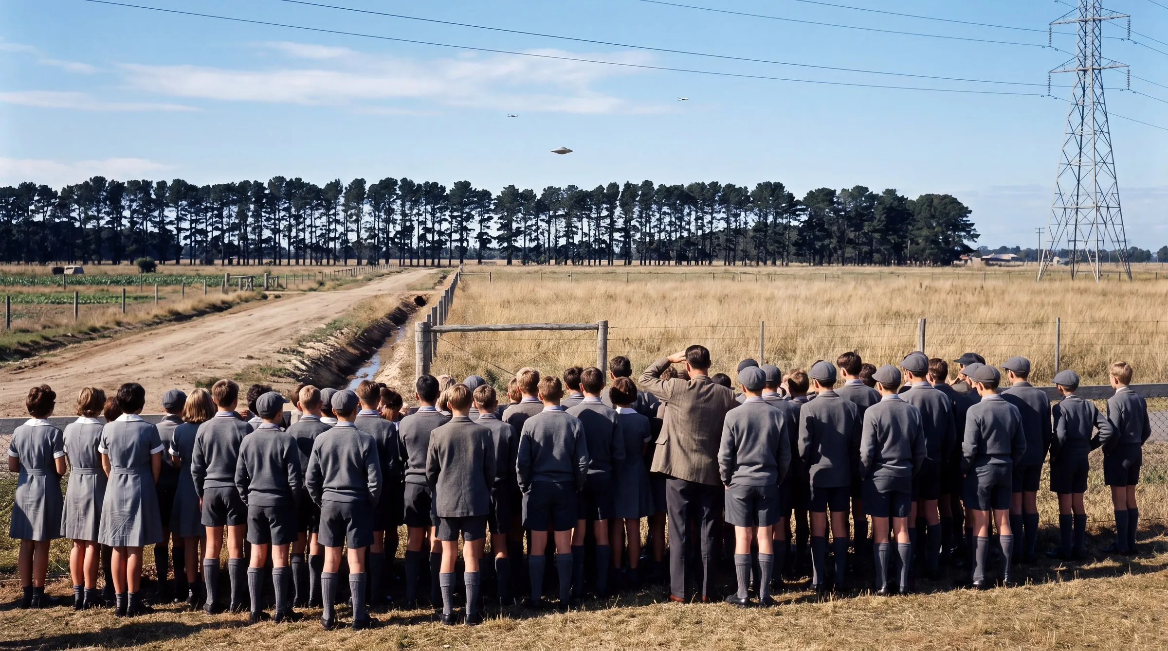
Stand on the oval and the 25 m pines 510 m away rise 2.4° above your eye; an object 20 m over the paddock behind them is hidden from both schools and 8° up from the children who ran into the Grange, exactly the sequence the accounts give. It is one to two Moons wide, and a 12 m parachute canopy in the same place is one to two Moons wide too: the geometry cannot refuse the balloon. The physics can. On the soundings of 6 April 1966 the wind over Mildura was westerly at every level and a balloon lands in the Riverina; a 200 kg load under 12 m sinks at 6.3 m/s and cannot rise; and the US assay tables show flight 292 flown and recovered on 5 April. One paddock, two channels, two readings.
 Open the interactive ▸
 What you're looking at
The Paddock is the site in three dimensions, the two school grounds, the Grange, the heathland remnant, the golf club, the 220 kV line and Fairbank Road's dirt, on the real relief, with the Sun where it stood at 10:20. An object of the dial's size sits at the dial's height and place; a sight line runs to it from each of the three witness groups, solid when the object is in view and dashed when the pines cut it. Stand at any of the three eyes, or at the object looking back. Switch the object to the parachute and a 12 m canopy with its gondola takes the same air. The ledger of angular sizes runs alongside: the disc, Greenwood's two-thirds of a Cessna, the canopy, the gondola, a Cessna at a kilometre, the Moon.
The Drift is south-eastern Australia from Adelaide to Canberra with a balloon flown on the radiosonde record of 5-6 April 1966: launch hour, float altitude, time at float and ascent rate on dials, Mildura's own profile below its top and the network's stratospheric composite above it, or Laverton's profile, or the single kindest report in the whole network held for the whole float. The track is coloured by phase, the landing is marked with its distance from the Grange, the dashed vector shows what the hypothesis needs, and The Age's Laverton weather balloon flies alongside on Laverton's own profile. The profile panel lists every level with the direction it blew from, its speed, and how far it carries a parcel in twelve hours.
The Clock is the parachute from float to ground: altitude and sink rate against time, the 8,000-5,000 ft band in which the crew reckoned a canopy visible, the 15-25 minutes the witnesses watched drawn at the ground, and a calendar of 5-6 April 1966 with flight 292 as the US record has it, the dial's flight, The Age's balloon and the sighting. Beside it a ledger of what a parachute does: its sink, its minutes, the updraft it needs to hold or to climb, the speed 'gone in seconds' requires, the envelope's size at float, sample 2272, and the airport 9.6° off the line. The File runs twelve cards, the documents first, then the site, the pines, the size, the airport, the hypothesis, the winds, the drift, The Age's balloon, the clock and the US record, then two readings at equal size.
Why it's here
On this site the case is a centrepiece of the Australian record in the In Plain Sight review and has its own wiki entry: on 6 April 1966 more than a hundred students and teachers at Westall, Melbourne, watched a silver-grey object over the paddocks south of the school go down behind the pines of the Grange, rise again and leave; Shane Ryan later logged 122 witnesses. By the time Coulthart wrote it up it was a case with no official file at all: no Australian government UFO record carries the word Westall. In 2014 the researcher Keith Basterfield put the one physical explanation with numbers attached: a Project HIBAL stratospheric sampling balloon from Mildura, its 200 kg gondola coming down under a 12 m parachute, a chase aircraft overhead and a Department of Supply crew on the road; flight 292, scheduled for 5 April, has no entry in the chase pilot's logbook, and the file series that would say where it landed was destroyed in 1996. Bill Chalker answered the same year: the retrieval crew's man said 292 never launched, and the Prime Minister's Secretary's classified memo a month later says nothing about a gondola in suburban Melbourne.
It is here because the case happens to split into two channels that need different physics, and no bench on the site was built that way yet. The first is geometry: three groups at three known places with a row of trees between, where every question is an angle and angles can be measured. The second is the balloon hypothesis, which supplies a launch site, a date, a payload, a canopy and a descent time, each of which can be run: fly it on the soundings of the morning, time the canopy's sink, and read the sampling tables the American side of the programme kept. The two channels come out differently: the geometry admits any object of that size, a canopy included; the winds, the clock and the record each refuse the parachute, and one of those three is new, the Mildura flight of 5 April 1966 coming home with a sample number in the US assay tables. After the Kaikoura Lights this is the second two-channel casework bench; the drift integrator descends from Project Mogul, the first-person sight-line scene from the Rendlesham Light.
How it works
Everything on the bench is arithmetic on a measured map, a measured atmosphere and a measured wind field: the sight lines are plane trigonometry from three eyes, the parachute is a drag law through the standard atmosphere, and the drift is the day's soundings integrated in height and time. The script that ships with the site re-derives every displayed number before the build passes.
θ = 2·atan(D / 2R) · hidden if atan((h_obj − h_eye) / d) < atan((h_pines − h_eye) / d_row) · v = √(2mg / ρ(h) C_d S₀) · t = ∫dh / v · dx/dt = u(h, t), dy/dt = v(h, t)
The sight lines. Each group stands at ground level plus 1.5 m at the edge of its grounds nearest the paddock; the object is at ground plus the dial's height, at the dial's place. Bearing, elevation, range and angular size follow; the pine row along the Grange's northern edge is a screen of the dial's height, and the object counts as hidden when its elevation is below the row's along that line. At the defaults the row stands 2.4° up from the oval and the object 1.5°: hidden from both schools, 8° up from the Grange, 0.90° across.
The parachute. A flat circular canopy of the dial's diameter with a drag coefficient of 0.78 on its nominal area, under the dial's payload plus 15 kg of canopy: terminal velocity 6.25 m/s in sea-level air, 41 m/s at 27 km, and a descent of 35 minutes from flight 292's recorded float, the last 8,000 ft taking six. The updraft needed to hold height is the sink rate itself; to climb at 5 m/s, 11.3 m/s. The record's 'about an hour' is on the dials: 200 kg under 20 m, or 120 kg under 16 m.
The drift. The balloon leaves Mildura at the dial hour, climbs at the dial rate, floats at the dial altitude for the dial duration, is cut down and descends under the canopy, each step through a wind interpolated in height within a sounding and in time between Mildura's ascents of 15:00, 21:00, 03:00, 09:00 and 15:00, with the network's 100-10 hPa composite above Mildura's top. At the defaults (07:00, 27.1 km, two hours) it lands at 11:16, 152 km east of Mildura and 444 km from the Grange; across every launch hour, altitude, duration and profile on the dials, with the float capped at the programme's eight hours, it never comes within 340 km.
Nothing is fitted. The only choices are the dials the record left open, the group positions within their grounds, and the composite above the soundings' top, each set the way most generous to the hypothesis; every finding quoted survives the whole range of all of them.
The dials that decide what happens
The object's height, size and place, the pines' height; the balloon's launch hour, float altitude, time at float, ascent rate and wind profile; the payload, the canopy and the seconds to the horizon. Between them they draw every version of the morning the record could mean.
- Height above the paddock. 0 to 150 m; 20 m by default, 'just above the trees, then behind them'. Slide through the pine line and watch the sight lines switch from dashed to solid.
- Size. 3 to 30 m; 9.2 m by default, 'the size of two cars'. Two-thirds of a Cessna is 5.5 m; a 12 m canopy is a notch to the right.
- Behind the pines, and east-west. Where the object sits relative to the row, from 60 m in front to 300 m behind, and across the paddock. The Grange group's angles move fast; the schools' barely.
- Pine height. 12 to 35 m; 25 by default. No record gives it. The hidden band moves with it and never disappears.
- The balloon. Launch from dawn on 5 April to mid-morning on the 6th; float 50,000 to 110,000 ft, 88,900 ft (27.1 km, flight 292's) by default; time at float 0 to 8 hours, the programme's longest schedule; ascent 3 to 7 m/s; the Mildura record, the Laverton profile, or the kindest single report.
- The parachute and the departure. Payload 50 to 400 kg (the record's 200, its measured 254); canopy 6 to 20 m (the record's 12); and the seconds the witnesses give the object to reach the horizon, which the bench reads back as a speed.
The claims, as they stand
The accounts and the explanations one by one, with where each lands when the geometry is run, the balloon is flown and the record is read.
| A silver-grey object over the Grange, down behind the pines, up again, gone proposed by the 1966 accounts: Tighe, Greenwood, the Journal, the Clayton Calendar | CONTESTED | Three groups at three known places on one bearing. The geometry reproduces the sequence with any pine height on the dial: an object 20 m over the paddock behind a 25 m row is 1.5° up from the oval against the row's 2.4°, hidden from both schools and 8° up from the Grange. It subtends 0.9°, one to two Moons, whatever it was. |
| 'Elevation: 45 deg' on the report form proposed by Joy Tighe, 7 April 1966 | READING | The only elevation in the record. At the Grange's distance it means 584 m up; at the dial's height, 15 m away. Every account has the object low over the pines, so the bench prints it and builds nothing on it. |
| Five light aircraft circling the object proposed by every account; the Dandenong Journal, 21 April 1966 | MEASURED | Moorabbin Airport bears 219° from the oval, the Grange 210°, 9.6° apart, with circuits 2.8° up: the same patch of sky. The airport confirmed a dozen departures that morning on circuits to the south-east of the strip; the RAAF had none. The aircraft need no object to explain them; they do not explain the object. |
| A HIBAL sampling payload under its 12 m parachute proposed by Keith Basterfield, 2014 | REFUTED | Priced three ways and refused three times: no level measured on 5-6 April blew from the north-west (a Mildura balloon lands in the Riverina, never within 340 km); a 200 kg load under 12 m sinks at 6.3 m/s and cannot hover, rise or turn against the wind for a quarter of an hour; and the US sampling tables show flight 292 flown, terminated and assayed on 5 April, with no flight on the 6th. |
| 'Object perhaps balloon': a Laverton weather balloon on a westerly proposed by The Age, 7 April 1966 | REFUTED | Laverton to the Grange is 34 km on 107°, needing 5 m/s from the WNW for two hours. Laverton's own 09:00 profile runs 230-270° at 10-40 m/s; a radiosonde climbs at 5 m/s. At 10:20 it was 15 km up and 90 km east-north-east of the school. |
| Flight 292 was never launched; its records are gone proposed by Chalker's informant, 2014; Basterfield, 2014 | MEASURED | The Australian series MP1472/25 was destroyed in 1996 and the logbook has no 292. But HASL-174 and HASL-182 list a Mildura flight on 5 April 1966 at 27 km whose filter was recovered and assayed as sample 2272, and StratoCat gives it as HIBAL-292, launched and terminated 5 April. It flew, the day before, and came home; its hour and landing place do not survive. |
| A ring of flattened grass, 25 feet to 10 yards across proposed by the Clayton Calendar; Tighe; Magee (VFSRS) | READING | Photographed by the VFSRS on Good Friday; the photographs and notes can no longer be found; Greenwood walked to the site and saw nothing; later figures run to 37 m and up to ten circles. The bench draws the ring under the object at the form's ten yards and records that the trace evidence is a memory of a photograph. |
| What the two channels amount to proposed by this bench | READING | One channel closes: the balloon is refused by the winds, by the clock and by the record. The other stays open: something one to two Moons wide, 600 m away, behind and above the same pines, for a quarter of an hour, in a record of four documents that disagree on shape, sound, count and time. The bench prices; it does not vote. |
Try this
- Start on the overview. Three sight lines, two of them dashed. Read the chips: 1.5° up from the oval against the row's 2.4°, 8° up from the Grange.
- Go to the oval. Raise the object to 40 m and it clears the pines; lower it to 20 and it drops behind them. Notice Moorabbin's chip 9.6° to the right of the Grange.
- Switch to the parachute. From the oval the canopy is 1.2° across, the disc 0.9°. Stand at the Grange: the canopy is a tent.
- Go to the Drift. Fly the defaults and read the landing. Then set the profile to 'best case', the launch to 5 April 09:00 and the float to eight hours, and read the closest approach.
- Find The Age's balloon. The dotted track from Laverton; click its 10:20 marker.
- Go to the Clock. Read the sink, the minutes and the updraft to hold height. Halve the payload: still sinking. Then click flight 292 on the calendar.
- End on the File. The form, the Journal, the site, the pines, the size, the airport, the hypothesis, the winds, the drift, The Age's balloon, the clock, the US record, then both readings.
Accuracy
The honest line between what is reported, what is measured, what is modelled on them, and what is a reading:
| Feature | Status | What that means |
|---|---|---|
| The site, the soundings, the sampling tables | Measured | OpenStreetMap footprints of the two school grounds, the Grange, the heathland remnant, the golf club, the 220 kV line and its towers, on SRTM relief; every wind from the IGRA radiosonde record of 5-6 April 1966 (Mildura's five ascents, Laverton's full profile, 23 stratospheric reports from five stations); Melbourne's surface observations; the HASL-174 and HASL-182 Mildura tables; StratoCat's flight list. Each carries its source. |
| The geometry and the atmosphere | Exact | Bearing, elevation, range and angular size by plane trigonometry from each group's eye; occlusion by the pine screen; the ISA layers; terminal velocity √(2mg/ρC_dS₀); the descent integral; the drift integral in height and time; the Sun's place at 10:20 AEST. No parameter is fitted. |
| The dials; the group positions; the composite | Modelled | The object's height, size and place, the pines' height, the balloon's float altitude, envelope, ascent rate and time aloft, and the canopy's drag coefficient are dials; the three groups stand at the edges of their grounds nearest the paddock; above Mildura's profile top the network's stratospheric composite is used, thin at 10 hPa. Every finding quoted survives the whole range of all of them. |
| The 1966 documents and the 2014 hypothesis | Reported | The report form of 7 April 1966, the Dandenong Journal of 14 and 21 April, The Age of 7 April, the Clayton Calendar, the McDonald-Greenwood notes of 1967, quoted as transcribed; Basterfield's payload, canopy, descent time, flight number and file history as he states them; Chalker's informant; John Sutcliffe in 2026. |
| What it amounts to | Reading | Whether a case whose geometry cannot name the object and whose one physical hypothesis fails three independent tests is an unidentified object or an unrecovered document is a reading, and the bench declines to make it for you. |
In one line: Every angle is plane trigonometry on a mapped site, every wind is a sounding from the morning, every sink rate is a drag law in the standard atmosphere, and the flight record is the US assay table with its sample number; the only dials are the ones the record left open, and the findings survive all of them. The 1966 documents are quoted as transcribed. The reading is yours.
Sources
- Keith Basterfield (comp.), "Westall, 6 April 1966: the original documentation", Project 1947, version of 28 July 2012: the VFSRS report form of Joy Tighe (7 April 1966), The Age of 7 April 1966 p. 6, the Dandenong Journal of 14, 21 and 28 April and 5 May 1966, the Clayton Calendar (Term 1, 1966), the APRO Bulletin (May-June 1966), and the notes of James E. McDonald's interview with Andrew Greenwood, Melbourne, 28 June 1967. http://www.project1947.com/kbcat/kbwestall.htm
- Keith Basterfield, "Project HIBAL: the answer to Westall? Files destroyed" (20 April 2014), "Westall, HIBAL: further information you may not know" (22 April 2014) and "Cold cases: Project HIBAL" (27 February 2011), ufos-scientificresearch.blogspot.com: the hypothesis, the 200 kg payload and 12 m parachute, flight 292 scheduled for 5 April 1966, the chase pilot's logbook, the destruction of NAA series MP1472/25 in 1996.
- Bill Chalker, "Westall, HIBAL and the balloon explanation" (21 April 2014) and "Westall '66: UFO or HIBAL? The answer is perhaps not blowing in the wind" (10 August 2014), theozfiles.blogspot.com; "The 1966 Westall Incident: Refuting the Official Explanation", New Dawn 173 (2019): the retrieval-team informant, the Prime Minister's Secretary memo of 6 May 1966 (NAA A6456, R190/017), the Herald Sun article of 6-7 August 2014 quoted verbatim.
- US Atomic Energy Commission, Health and Safety Laboratory, "Fallout Program Quarterly Summary Report", HASL-174 (Sept-Dec 1966), Table 3b, and HASL-182 (March-June 1967), Table 4b: "Stratospheric radionuclide concentrations, balloon samples collected during April 1966, latitude 34S Mildura, Australia": flight days 14, 5, 19, 27 at 24, 27, 32, 36 km; HASL number 2272 for day 5 at 27 km; the annotation scheme (?, #, A, *). osti.gov/servlets/purl/4463071 and /4226646.
- StratoCat, "Australian Balloon Launch Station (ABLS), Mildura, Victoria" and the 1966 flight records (stratocat.com.ar/bases/42e.htm; globos/1966/e9152.src): HIBAL-292 launched 5 April 1966, float 27.1 km, terminated 5 April 1966; HIBAL-285 payload 561 lb; level-flight durations of 20 minutes to 4 hours; the Piper Aztec chase aircraft.
- NOAA NCEI, Integrated Global Radiosonde Archive (IGRA) v2.2, data-por files ASM00094693 (Mildura Airport), ASM00094865 (Laverton RAAF), ASM00094672 (Adelaide), ASM00094711 (Cobar), ASM00094910 (Wagga Wagga), ASM00094821 (Mount Gambier), ASM00094659 (Woomera); underlying source NCDC DSI-6323 "Australian U/A Thermo/Winds Merged". Retrieved 4 September 2026. NOAA NCEI Integrated Surface Database, ISD-lite 1966, stations 948650 Laverton, 948680 Melbourne Regional Office, 948640 Essendon, 946930 Mildura.
- Shane L. J. Ryan, "An Ongoing Mystery: The Westall Flying Saucer Incident", Kingston Local History (11 June 2012): the timeline, the 485-student roll, the PE classes at 10:15, the pylons on the school grounds, the dirt of Fairbank Road, the pines of the Grange, the Channel Nine crew, the assembly.
- ABC News / Australian Story, "The Westall UFO mystery: sixty years on, witnesses still want answers" (6 April 2026): Shane Ryan's 2026 counts (142 sky, 197 ground marks, 77 both), John Sutcliffe of the Mildura HIBAL team, Shane Ryan on the Laverton balloon and the south-westerly. ABC News, "How balloons launched from Mildura helped the US sniff out top-secret nuclear weapons data" (9 April 2023).
- Charlie Wiser, "Westall" series (threedollarkit.weebly.com, 2022), drawing on Steven Thorn, "Project Hibal" (2021): balloon dimensions at float, payload 200-300 kg, the parachute "visible from 8,000-5,000 ft", cut-down and retrieval procedure, the NASA "special launchings" schedule (NAA A1838, 694/7/23 part 2), the Scoresby surface wind for 6 April 1966.
- Brian Dunning, "The Westall '66 UFO", Skeptoid #208 (1 June 2010); Matthew Sharpe, "Westall '66: 50 years on, still stranger than fiction", The Conversation (3 April 2016); State Library Victoria, "Strange lights in the sky: the Westall UFO event, 1966"; Wikipedia, "Westall UFO" and its talk page: the later witness accounts and the counts.
- T. W. Knacke, "Parachute Recovery Systems Design Manual", NWC TP 6575 (1992), Table 5-2: drag coefficient of a flat circular canopy 0.75-0.80 on the nominal area. US Standard Atmosphere 1976 / ISA layers to 47 km. Solar position by the NOAA (Meeus) reduction for 6 April 1966, AEST, no daylight saving.
- OpenStreetMap contributors (ODbL), Overpass API query of 4 September 2026: Westall Secondary College (way/63605710), Westall Primary School (way/63605708), The Grange Reserve (way/179139669), The Grange Heathland Reserve (way/559995882), Spring Valley Golf Club, the 220 kV line (way/239953881) and its towers, Moorabbin Airport (way/33542871). AWS Terrain Tiles (terrarium, SRTM 1-arcsecond) for the site heightmap and the south-eastern Australia base map; Copernicus GLO-90 as the bare-earth check.
Stand where they stood. Then fly the balloon they were offered.
Open the interactiveCompiled September 2026